

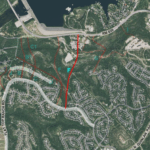
Travis County officials met strong opposition from local residents during a Dec. 5 meeting in Steiner Ranch when the county was looking for community feedback on the chosen evacuation route called F, marked on the map in red.
Note: The evacuation route will be discussed during a special combined Steiner Ranch Neighborhood Association and Steiner Ranch Master Association meeting on Tuesday, Dec. 11 starting at 6 p.m. at Towne Square 12550 Country Trails Ln.
By LYNETTE HAALAND, Four Points News
Local residents strongly opposed plans presented for a so-called Travis County emergency evacuation route during a presentation on Dec. 5 in Steiner Ranch. The proposed $7.1 million road that measures three fourths of a mile would connect RM 620 to Flat Top Ranch Road beginning near Westridge Park.
 Residents at the meeting who live near the proposed road, which is also called route F, said they do not want a permanent road there.
Residents reiterated multiple times that they were not informed when the county shifted the scope of the evacuation road project to emphasize a route that could also be used as a permanent, general use, continuous road.
 “Every invitation we received spoke only of a temporary evacuation road not a permanent, everyday use road,” said Josh Yates, whose house backs up to where the proposed route F would be. “If the county had been upfront and ensured we knew about these forums – we’d have been there in much larger numbers from the beginning.”
Some residents described the situation as “bait and switch”, and further they said they have not been given adequate opportunity to give feedback on the new idea of a permanent road.
“I think their minds were made up on a permanent road option, they conveniently buried that information and they were just checking the box on community input,” said Julie Snyder, who lives in the Estates of Westridge portion of Steiner. “I’m not convinced our opinions matter whatsoever to them.”
 Suzanne Hopson, who also lives in Estates of Westridge, was outspoken at the meeting.
“A through road with a traffic light won’t only be used by local Steiner residents. Flat Top will become a major thoroughfare,” Hopson said. “We will lose part of our park and the nature trail there. It will negatively affect property values as well.”
Comments like these and many more from the 20 or so residents in attendance at the Dec. 5 meeting were enough to slow down the county’s process.
Two days after last week’s meeting, Travis County postponed the open house, it planned to host at Vandegrift on Dec. 18, where the project was to be reviewed with the public prior to moving into the design and construction phase of the chosen route F.
 “Due to the amount of interest in the project, the Dec. 18 open house is postponed and will be rescheduled in January or February,” said Kathy Hardin, the engineer with Travis County Transportation & Natural Resources Capital Improvement Projects who is in charge of the project.
During that interim, Hardin said, Travis County will get information out to the community and provide a forum for discussion.
“We greatly appreciate the feedback that has already been received and look forward to more discussion as we continue to study the options,” Hardin said.
Also other meetings on the topic are in the works including one on Dec. 11 in Steiner Ranch.
Dec. 5 meeting
Along with residents and Hardin, officials from engineering firms who are working on the project and local emergency service agencies were present at the meeting on Dec. 5.
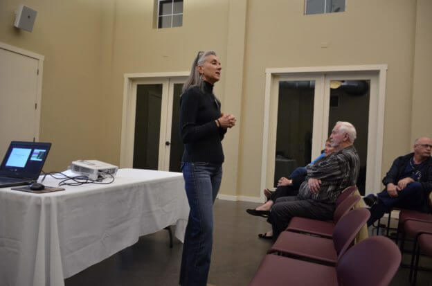
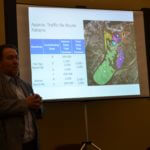
The meeting’s purpose was to inform and gather feedback about the chosen route F but it spun out of control not long after Steven Widacki, engineer from M&S Engineering, began the presentation.
The idea for an evacuation route gained momentum after the 2011 wildfires in Steiner where 23 homes were destroyed, he said.
“It took about seven plus hours for a full-scale evacuation in the area out of Steiner Ranch and along 620,” Widacki said.
As the county was looking at evacuation road options, the only logical direction out would be the northwest area of Steiner which is the closest proximity to RM 620, Widacki said.
Travis County developed and studied 12 routes since the $2.7 million funding passed in February 2017 for an evacuation route. At that time, one route was considered with potential of modifying it.
During the course of 18 or so months, the county received public input online from nearly 100 respondents on the project.
The county developed a decision matrix. Based on that, the county said that route F was decided upon at the agency stakeholder meeting which included Travis County Transportation & Natural Resources, emergency services and public safety officials.
“This group recommended route F,” Widacki said.
From the emergency service perspective, including the sheriff’s office and Lake Travis Fire Rescue, route F would get people out the fastest, Widacki said.
Compared to the other 11 routes, F is the straightest path.
Widacki presented the latest version of route F which would go along the edge of Westridge park and then through Steiner green space and Lower Colorado River Authority land to RM 620. But that version of route F was not on the website nor presented at previous public meetings.
“The county’s intent is to improve exit capacity in an evacuation event,” Widacki said. “This route (F) avoids existing homes and individual properties.”
But not long after he was going over the PowerPoint presentations, residents started asking questions and making comments. Motives, budget, responsible use of taxpayer funds, timeline, other emergency options, lack of community involvement and more were questioned.
Resident Snyder pointed out that F is one of the longest and most expensive routes of all of the options, according to the information on the website.
She pointed out that route F ranked second on the matrix after route C, which ranked highest. Route C is estimated to cost $2.1 million compared to route F at $7.1 million.
“Why is the highest ranking option, route C, not selected,” Snyder asked. “It was three times less expensive, less acreage disturbance, leverages existing roads, and 1/10 overall road length.”
But project leaders said they changed the multiplier and reduced the weighting on cost in their analysis.
“(Then) option F — the only permanent through road option — conveniently rose to the top,” Snyder said.
After some 45 minutes at the meeting, Hardin, who was in the back of the room because she was sick, came to the front and started fielding questions.
“I regret we didn’t get to you sooner,” Harden told the residents. “I understand your frustration.”
“I will always be upset if a permanent road is brought to my backyard,” Yates said.
Harden proceeded to share multiple reasons why F was chosen.
“We’re trying to get an option sooner rather than later,” Hardin said. “This is the area we can build now, in the next couple of years.”
The two-lane road would not require property acquisition from current or future homeowners and would not bisect a neighborhood, Hardin said.
There would be another signal light at its intersection on RM 620.
“It would be a great secondary alternate for bus routes for LISD,” she added.
 Added traffic to Flat Top
Ryan Bell, engineer at K Friese + Associates, started into his portion of the presentation on traffic.
“We have not done traffic counts of the actual streets yet so right at this moment we may not be giving the best data,” Bell said. “We’ll talk about reasonable assumptions. If it is open continuous, there will be some additional traffic.”
Making route F into a permanent road is estimated to add between 5,000 and 6,000 daily vehicle trips to Flat Top Ranch Road. This additional traffic is not currently using Flat Top but would come from middle and lower sections of Steiner and beyond up to Lake Austin.
More comments
Everytime more information was shared, residents had more comments and questions.
“Who is it that we contact to change course and correct this,” asked Brad Stanton, who lives in the Estates of Westridge and who sits on the Steiner Ranch Master Association HOA board.
Stanton asked if there was any research done or data to show that Steiner residents wanted a permanent road?
“We need to look at evacuation routes with an emphasis on no permanent road,” Stanton said.
Another resident stressed that a bridge over Lake Austin seems to be a better plan.
“A bridge over Lake Austin would cost tens of millions of dollars and would be cost prohibitive,” Widacki said.
Crossing Lake Austin is not feasible, Hardin said. “The terrain change is tremendous and the permit to do that is incredible.”
Several residents said this plan F does not solve the problem of a safety evacuation because everyone is “dumped out” onto RM 620.
“While this road may get us out of Steiner more quickly – all it really does is shift the traffic onto a road that already receives failing grades from TxDot for mobility,” Yates said.
“Their solution was not solving the real problem. The real issue is that Steiner needs another evacuation route that will relieve the back of Steiner, not yet another exit at the front to add to already congested 620,” Snyder said.
“Why are all of these exits onto 620. That’s not helpful to our community at all,” Hopson said. “We’re spending $7 million on something that doesn’t solve the problem.”
“You all are trying to fix something that should have been fixed by the (county) planning committee years ago,” said Jim Eagle, resident of Westridge. With all of the apartments and new building, that will add another thousand cars to the local roads, he added.
“During the last fire, F would have been in the middle of it,” pointed out Jannine Farnum, resident.
 Snyder is cynical about the process at this point.
“I’m sure that F was the recommendation because the firms engaged in the studies/recommendation want the most expensive option so they make the most money,” she said.
Prior to last week’s meeting
The county has been working on an evacuation route for years. On February 28, 2017, Travis County Commissioners approved $2.7 million in funding for an evacuation route using Certificates of Obligation. For years it has been referred to as an emergency only road.
There was one route identified and presented at that February meeting indicating it could be that route or a similar one. All was relatively quiet on the subject until an open house was held in Steiner on Aug. 9 this year when 12 routes were on display.
The county’s presentation of this project at meetings and on their website could be perceived as misleading as “evacuation route” is clearly messaged throughout the information. The website states “may be designed for public continuous use” but does not clearly reflect the change in scope to a permanent road.
Then there was a Sept. 5 internal stakeholder meeting with emergency services and environmental staff for the purpose of going over input from the community and reviewing the 12 routes more closely.
Hardin told Four Points News after that September meeting: “We are narrowing down the preferred routes, but funding is an issue for some of the preferred. Based on what we know now, we plan to meet with, at a subcommittee level, to go over preferred routes and funding possibilities to determine if additional funding is an option, is project phasing appropriate and other options. TxDOT planned work on RM620 could impact the recommendation for the preferred route.”
Then at last week’s meeting, Hardin said that in October, F came up to the forefront as the lead choice.
Looking ahead
Since Wednesday night’s meeting, the county is now looking to slow down the process of choosing an evacuation road out of Steiner.
Brian Thompto, Steiner Ranch Neighborhood Association chairman, is involved in the process and is making sure the community’s voice is heard and that more steps are taken in this decision.
The evacuation route will be discussed during a special combined SRNA and Steiner Ranch Master Association meeting on Dec. 11 starting at 6 p.m. at Towne Square 12550 Country Trails Ln.