
By RICHARD DENNEY
Travis County Historical Commission
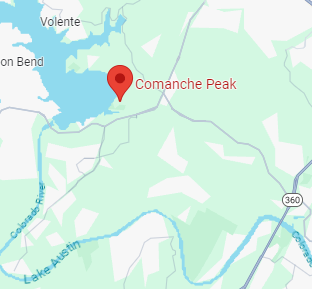
Comanche Peak in Four Points is the only peak in Travis County named after an American Indian tribe. Travis County Historical Commission had plans to erect a historical marker for Comanche Peak and now years later, that is done. The marker was installed in November at the intersection of Comanche Trail and Monte Castillo Parkway near the Oasis on Lake Travis. Comanche Peak’s high point is about a third of a mile southwest of the marker on Travis County property.
Today’s FM 2222 (historically known as Bull Creek Road) was part of a trail-become-road connecting Austin to Hamilton Creek in Burnet, a favorite campsite of the Penateka, our Central Texas division of the Comanche.
The new market is the only official State of Texas historical marker in Travis County dedicated to Native American geography. Here’s the marker text:
Comanche Peak
At Austin’s founding in 1839, Native American groups already living here included Apache, Waco (a branch of the Wichita) and Tonkawa. The dominant tribe was called Comanche; they called themselves Nʉmʉnʉʉ (“the people”). They controlled much of Central Texas since the mid 1700s, and their Comancheria homeland included much of what became Texas and the Southern Plains. Austin’s early history is inseparable from the history of the Penateka Comanche, the southernmost band who ranged along the Colorado River watershed from its headwaters through the hill country and into Central Texas. (Lake Travis, Lake Austin and Lady Bird Lake are all on the Colorado River.)
Rising more than 500 feet above the historic river level, Comanche Peak was part of an intricate network for transportation, communication and resources. Trails from here connected to other trails and geographical features of importance to the Comanche: fords at Santa Monica Springs and Shoal Creek; the pass at Mount Bonnell, and springs such as Seiders, Barton, Manchaca and Hamilton Pool. Segments of these historic trails at the base of Comanche Peak align with local roads such as Comanche Trail and Old Burnet Road that connected Austin to Burnet’s Hamilton Creek, a favored Comanche campsite. Peaks such as Comanche Peak were utilized by the Comanche for navigation, surveillance and signaling.
The Comanche continued to travel their extensive trail network regionally and locally as Austin began to grow in population. Just south of the peak, a canyon named Defeat Hollow recalls a circa 1870 skirmish between about a dozen Comanche and Joel Arthur Harris, an early Hudson Bend settler. As the only Peak in Travis County named for an American Indian group, Comanche Peak’s location helps us better understand the Comanche geography of Travis County and their trail system into Austin along the Colorado river.
Richard Denney is Vice-Chair of the Travis County Historical Commission. For more on this topic and other local history, visit traviscountyhistorical.blogspot.com/
Old Burnet Road: Mt. Bonnell to Comanche Peak and beyond
Blog by RICHARD DENNEY
Travis County Historical Commission
Janet Long Fish in an oral interview in 2000 speculated on the connection between the north-south Comanche trail along Shoal Creek and the trail to Mount Bonnell, on past Bull Creek to Comanche Peak. In this blog I’ll elaborate on that topic. The connection was a road to the general area of today’s Burnet, Tex. (Burnet is some 60 miles northwest of the Four Points area.)
While we have here in Austin (in Four Points) a road today called “Comanche Trail” running next to Comanche Peak by Lake Travis, I think it’s relevant to look at the bigger picture and consider the road of which today’s Comanche Trail was a part. That road is (or was) one of two roads connecting Burnet and Austin. Segments of that old road still exist by Lake Travis as Old Burnet Road.
The Penateka, our local division of the Comanche, called the headwaters of the Colorado River home. (Lake Travis, Lake Austin and Lady Bird Lake are all on the Colorado River.) It was near Colorado City, Tex. John Moore attacked a village of Comanche in 1840. That attack was the culmination of a string of conflicts that year between Texans and Penateka beginning with what is variously called the Council House fight or massacre; followed by a revenge attack by the Penateka on the towns of Victoria and Linnville; followed by the battle at Plum Creek. The attack by John Moore was intended to take the fight to the Penateka in their homeland.
Along the swath of the Colorado River and its tributaries closer to Austin, the area of Burnet, Tex. was a favored campsite, hence the reason for Fort Croghan’s location. In 1847 Texas Rangers under Henry McCulloch (Ben McCulloch’s brother) set up a camp south of today’s Burnet to disrupt Comanche occupation and protect settlement. The location was later moved north of Hamilton Creek at the base of Post Mountain and became U.S. Fort Croghan. As was often the case, where there was a fort, a town sprang up giving us today’s Burnet, Tex. (originally called Hamilton Valley as is shown on some old maps).
Texas A&M Forest Service’s official Indian Marker Tree was located on Hamilton Creek, near the fort, in Burnet. From their website: “In the fall, [the Comanche] passed through Central Texas and one of their favorite camping spots was along Hamilton Creek which flows through Burnet”
Comanche Chief Yellow Wolf made appearances at the fort, had his portrait painted there, and camped near what would later be the site of Gabriel Mills. It was atop nearby Mt. Gabriel, AKA, Pilot Knob, a mesa and highest point in Williamson County, Comanches said to have been associated with Yellow Wolf watched the approach of the ill-fated Webster wagon train in 1839. It was Yellow Wolf, camped near Gabriel Mills, Frank Dobie wrote about in his classic Coronado’s Children telling tales to Samuel Mather of a silver mine “three suns to the West”.
Burnet Road(s) are from a time when roads were named for their destination, in this case Burnet, Tex. From Austin, there were historically two Burnet Roads. The “high road” was east of the Colorado, out of the river valley and the route most travelers today would take; it is the general route of today’s US 183 / SH 29. On this route was Tumlinson’s blockhouse fort, built 1836, burned by the Comanche in 1837. On this route was the attack on the Webster wagon train by Comanches in 1839 near today’s Leander. And this route was also known as the “military road” which ran through Bagdad, so-called because it was the road to Fort Croghan. Not much is left of Bagdad today but the cemetery.
But there was a second “Burnet Road”. Any traffic into Austin down the Colorado river valley would, of geographic necessity, probably have tracked this route which I’ll refer to as Old Burnet Road as there are remnants of that road by that name around Lake Travis. A GLO map surveyed in 1877 shows the length of the road. The skirmish at Defeat Hollow, near Comanche Peak, between Joel Harris and Indians (probably Comanche) had occurred only years before this map was surveyed, probably ca. 1870. It is likely today’s Comanche Trail (the road) was a side road off this longer road; i.e. a pull-off from the main road to reach the top of Comanche Peak. Comanche Peak may well have been what the Spanish called a “paraje”; a stopping / camping place along a longer trail. And a review of the earliest known aerial photo of Comanche Peak, taken in 1937 by Tobin Imagery, shows today’s road, Comanche Trail, was indeed just a trail in 1937.
Starting from Austin, Old Burnet Road was today’s 2222 to Four Points, then straight ahead on what is today Bullick Hollow Road It ran to Anderson Mill, to Volente, Travis Peak and on to Burnet. Parts of the road emerge from Lake Travis today (in Google Maps search for “Old Burnet Road, Leander, Tex.”). Commissioners Court Minutes show the route between Anderson Mill to Burnet (then still called Hamilton Valley) being discussed as early as 1853 [Commissioners Court Minutes, book B, p.39].
Mt. Bonnell was a historically referenced entry to Austin for Native Americans. Julia Lee Sinks talked of the “beaten track of the Indians into town from the pass of Mount Bonnell”. Of Bigfoot Wallace’s refuge in the cave on Mount Bonnell, when asked why there, he responded “Well … the cave was right on the old Indian trail leading down to Austin”. It was route of escape of Indians (probably Comanche) that abducted the Simpson children from West Pecan in 1844. Old Burnet Road was the road that connected Burnet to Mt. Bonnell, passing at the base of Comanche Peak.
Old Burnet Road is probably the most significant route coming down the Colorado River in connection with Comanche Peak because it passes at the foot of the Comanche Peak. But once there Comanche Peak would have been a jumping off point for other trails. In particular there was likely a trail from Comanche Peak to Santa Monica Springs, said to have been a Comanche watering stop, and a ford across the Colorado leading to trails tracking today’s Bee Caves Road.
Richard Denney, vice chair of the Travis County Historical Commission, posted this blog on July 5, 2020 on traviscountyhistorical.blogspot.com/