
Lake Travis, Lake Austin affected
By LYNETTE HAALAND, Four Points News
The last of the four Mansfield Dam floodgates will be closed around Nov. 7 or so as the Lower Colorado River Authority manages floodwaters in the system of lakes feeding into Lake Travis.
“Based on current circumstances, the floodgates will be open until early to mid November,” said Phil Wilson, LCRA general manager, last weekend.
The historic flooding event has impacted the Four Points area which is home to Lake Travis and Lake Austin. Both lakes have been closed since the flooding began.
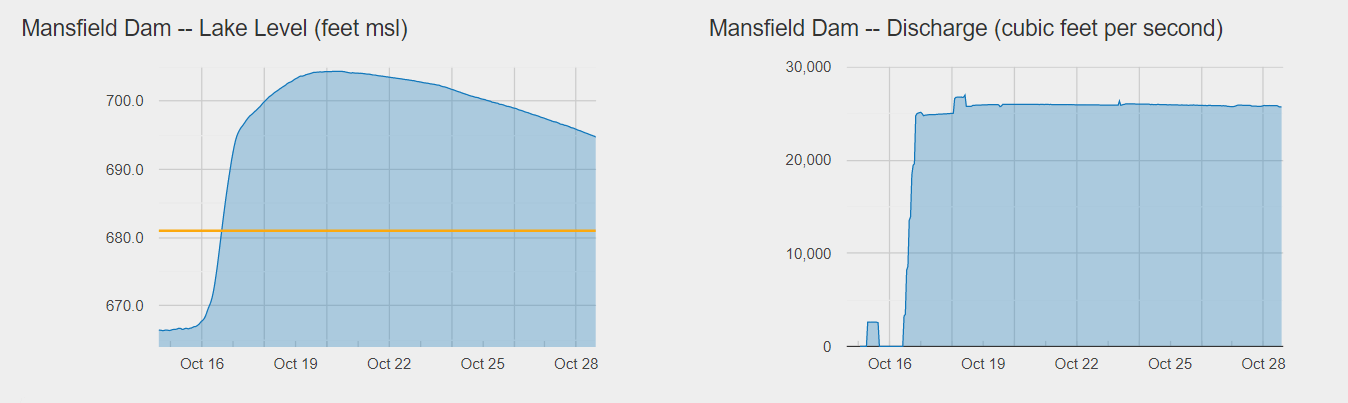
“One week following the flood on (Oct. 16), we had put as much water into Lake Travis that the city of Austin uses in a four-year period,” Wilson said. “Some which we’ve stored and some we sent downstream to get water out of the flood pool in an efficient, safe manner after the flood.”
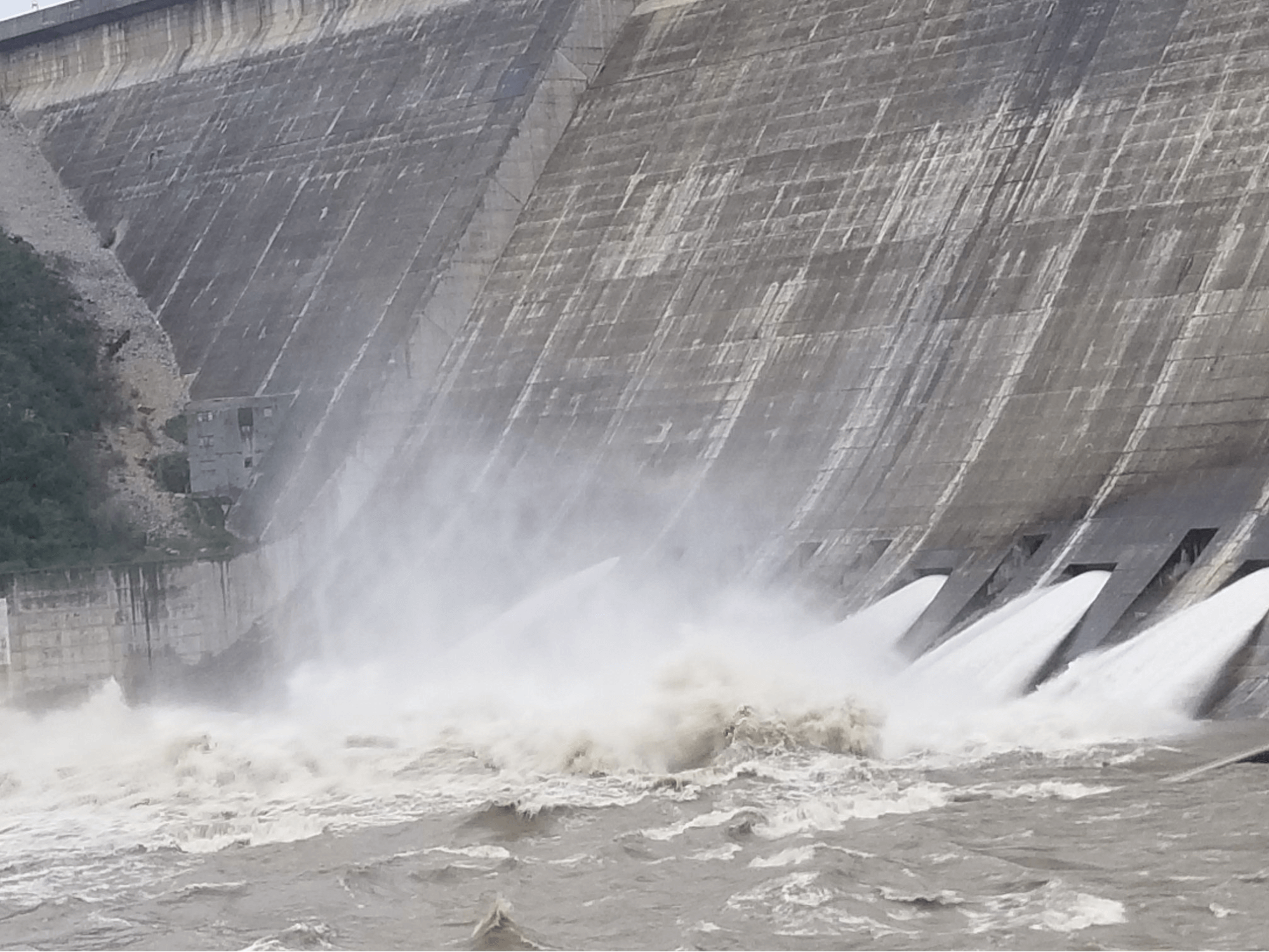
The Lower Colorado River Authority manages Lake Travis and opened four floodgates on Oct. 16 to make controlled releases from the flood pool of Lake Travis to manage river levels downstream of Mansfield Dam.
Lake Travis water levels are dropping by approximately 2 feet a day. On Sunday, Oct. 28 at 10:30 p.m., the lake was at 694.31 feet above mean sea level. That is down some 10 feet from eight days earlier when it reached its fifth highest level in history at noontime on Oct. 20 when it was 146 percent full at 704.39 feet msl.
By Monday, Oct. 29 it was expected to drop to 691 feet msl.
The flood waters are taking their toll on those who live on and have businesses on Lake Travis and Lake Austin including River Place, Steiner Ranch, River Bend and so on.
While Lake Travis is dropping, Lake Austin levels are staying constant at around 7 feet to 8 feet above normal levels, according to Kim Waters, who lives on the lake in Steiner Ranch.
Boat docks are covered with water affecting electrical wiring which will likely cause several thousand dollars in repairs for homeowners, Waters said.
Also early on when Lake Austin was rising, some homeowners were affected by docks or boats that came loose and were floating down the lake, bumping into other boats and/or docks.
“Most most of us have pumps in the lake that we pay a yearly fee to use to water our yards. These pumps cost between $5,000 – $8,000. Last time they opened the gates two years ago several people lost their pumps,” Waters said. She expects that there will be a lot of pump repairs or replacements because of all of the debris.
Also Waters said that erosion will be a concern. The city of Austin doesn’t allow them to build a sea wall, she said.
Lake Austin levels are expected to remain high until after the floodgates are closed.
“We are discharging 25,000 cubic feet per second at Mansfield. Lake Austin will stay fairly level until we close the floodgates,” Wilson said.
There is a formula to determine when LCRA opens floodgates, where they are opened and how many are opened in one of its dams.
“There is a protocol we use by the Army Corp of Engineers. (During this event,) the system worked exactly how the system is supposed to work,” Wilson said.
There are many calculations and projections used when LCRA decides to open floodgates. The U.S. Army Corp of Engineers uses the National Weather Service and LCRA has a weather forecast center, other factors include ground saturation and lake capacities.
“All things are taken into account and under consideration,” Wilson said.
LCRA’s goal will be to get Lake Travis back to full at 681 feet and not have excess water in Mansfield’s flood pool.
“The flood pool is for the flood pool, that was is it built for,” Wilson said.
Around Nov. 9 or so, LCRA will close the floodgates at Mansfield Dam when Lake Travis is full.
LCRA is constantly monitoring the flood operations while it sends water downstream. It is watching the levels at Lake Travis and all of the other Highland Lakes – Buchanan, Inks, Wirtz, Starcke and Tom Miller. Flooding rains and historic inflows into the lakes early in the week of Oct. 15 caused fast, high flows on lakes Inks, LBJ, Marble Falls and Austin as well as lakes Buchanan and Travis.
Wilson said LCRA uses drones, helicopters, physical checks, and more to constantly monitor the flood operations.
This has been a massive event. So far this flood has had 1 million acre-feet of water running through all of the lakes and dams in the Highland Lakes system, Wilson said. That is the equivalent to a full Lake Travis, which holds 1.13 million acre-feet or the amount of water it would take to fill more than 1.1 million acres to a depth of 1 foot.