


By LESLEE BASSMAN, Four Points News
Six or so years after Leander ISD Board of Trustees President Pam Waggoner advocated the idea as a safety measure for students and faculty landlocked with a single access point, a secondary road to Vandegrift High School received unanimous approval from Austin City Council today, Thursday, April 11.
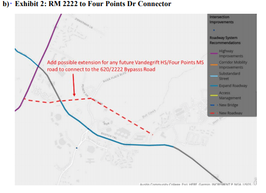
This secondary access road is to be built without traversing Balcones Canyonland Preserve.
Introduced by District 6 Council Member Jimmy Flannigan as an addendum to the Austin Strategic Mobility Plan, the city’s transportation plan, the measure adds a road from the campus to the RM 2222 bypass now under construction. However, unlike other proposed projects, this route does not cross federal preserve land, confirmed Flannigan’s communications director Kate Messer.
“The road runs parallel to 2222 and would connect McNeil Rd to Four Points Dr/River Place Blvd through the 3M property,” Flannigan stated. “It may also further connect to the current bypass road project that TxDOT is constructing, but that adds more challenges.”
Although the road is in the city’s plan, as with the ASMP’s other projects, it is not funded yet, Messer said.
“Council Member Flannigan successfully amended the Strategic Mobility Plan to include a new road connecting to the Vandegrift campus,” Messer said. “Clearly there is still more work to do as the plan does not identify funding but it does confirm the city of Austin supports taking responsibility for this road.”
The road amendment to the Austin Strategic Mobility Plan (ASMP) proposed by Flannigan is “not (an) engineering document,” detailing specifically where the road will go, Flannigan told Council.
“This is a road project that’s really important to the northwest of town because the high school and middle school campuses only have one road in and one road out,” Flannigan said.
The proposed road runs through the 3M property, which has been sold, where there are already road connections, he told the council.
Mayor Pro Tem Kathie Tovo cautioned about a road that is near salamander habitat and Bull Creek. Assistant Director of Austin Water Utility Daryl Slusher said city staff studied the path of the Vandegrift road this morning (April 11) and confirmed its route “does not go through any public or private preserves.”
“This is not about putting a road through protected lands or any other preserved lands,” Flannigan said.
The item was also supported by Council Members Alison Alter of District 10 and Leslie Pool of District 7 who is the chairman of the Balcones Canyonland Conservation Plan Coordinating Committee.
Quoting from a constituent’s email, Pool called Flannigan’s proposal “an elegant solution to what is a horrifying mess.”
According to an April 11 city of Austin news release, the Austin Strategic Mobility Plan (ASMP) is the city’s first locally focused transportation plan and replaces the 1995 regional Austin Metropolitan Area Transportation Plan. It guides the city’s transportation policies, programs, projects, and investments, and also amends the transportation element of Imagine Austin, the city’s comprehensive plan.
“Carrying out the ASMP will build connections, improve our current systems, increase accountability, and plan for Austin’s long-term transportation future,” the release stated.
The Austin Strategic Mobility Plan (ASMP) includes policies on transportation safety, demand, infrastructure, operating Austin’s transportation network, health and environment, supporting the community, and implementation. It features interactive maps on the city’s roadway capacity projects, sidewalk prioritization, public transportation, bicycle system, urban trails, and high-injury network, the release stated.
