By LYNETTE HAALAND
Four Points News

The Travis County Transportation & Natural Resources department has a preference to move forward with route F as a new permanent road for Steiner Ranch. The near one-mile, $7.2 million road would cut through the greenbelt to connect Flat Top Ranch Road with RM 620, intersecting RM 620 close to Mansfield Dam.
“TNR has a preference and route F is the preference,” said Kathy Hardin, an engineer with Travis County Transportation & Natural Resources Capital Improvement Projects. “This is the route of least resistance.”
But those working on the project will be open to considering other ideas at the Travis County Steiner Ranch Area Evacuation Plan Open House on Thursday, April 18 at Canyon Ridge Middle School at 12601 Country Trails Ln. from 6 p.m. to 8:30 p.m.
“We will have the open house and see how that goes. We’ll maybe get new information that we don’t know yet,” Hardin said.
After evaluating information after the open house, if TNR still confirms that route F is its preference, then it will go before the Travis County Commissioners.
“Once we feel like we’re comfortable moving forward, we will take it to the commissioners to move forward,” Hardin said. They plan to share their preference — barring any changes — of route F, but they will also be prepared to talk about the other two leading routes up for consideration (B and G) with the Travis County Commissioners, she added.
Hardin expects to go before the commissioners pretty quickly, like within the next month or so.
David Greear, assistant public works director in the engineering division at Travis County – Transportation and Natural Resources, and Steven Widacki, engineer from M&S Engineering, LLC recently discussed reasons behind their preference of route F with Four Points News.
Why only RM 620 route options
Greear, who lives in the Four Points area, said the county looked at so many ways to get in and out of Steiner. The greenbelts in other directions away from RM 620 are Balcones Canyonland Preserve lands, he said.
“We cannot cross them, don’t have the option,” Greear said. They looked at crossing Lake Austin but BCP land is on the other side as well as Michael Dell’s property. They looked between Steiner and River Place and again that was surrounded by Balcones, he said.
“These (lands) are already purchased with federal dollars,” he said. “We don’t have an option (to go through them).”
When developers mitigate land, that’s negotiated at the beginning of a project, he said. “(For Steiner,) we cannot trade it, it’s locked in.”
“This (going toward RM 620) option is the only this way,” Greear said.
There are strict guidelines when it comes to mitigating preserve land and in many cases, owners or developers have to “mitigate four times the amount they took,” he added. “I think it’s impossible.”
Whittled down to three options
The county received a lot of push back from the community when it presented its recommended route F in early December. After that, it shifted to reconsider two other options.
Over the past several months, the county has been focusing on three of the initial 12 routes that it first proposed.
One of the main reasons Travis County liked route F last fall was that at an internal stakeholder meeting with 16 first responders, the responders overwhelmingly voted on route F as the best option for them out of the dozen choices, Hardin said.
“The county never wants to take people’s homes,” Greear said. “If there is not another option, we will but we don’t want to when there are other options. We have so many other options.”
No private property
One of the most appealing things to Travis County officials about the route F option is that it does not involve private property.
Steiner Ranch Master Association owns a large part of the land it would go through.
“It’s all SRMA and Travis County property,” Greear said. “The SRMA land, we’d be purchasing from them.”
The route would connect RM 620 at a site that Travis County owns. It purchased the site from the Lower Colorado River Authority some three years ago. The county service center is located there now ,which is a fueling station for first responders of the county including fire, EMS and the sheriff’s office.
Evacuation capacity
Greear said that in an emergency situation — unlike the fires of September 2011 when all of Steiner was evacuated and the traffic had to go right on RM 620 because the fire started toward the Mansfield Dam direction — an alternate route coming out and “splitting that traffic is lots easier. It gives you options.” Routes F, B and G and all have that option, he added.
Additionally, the three routes that are being considered each have at least 750 cars per hour per lane evacuation capacity based on studies done.
Contra flow would allow route F to have 1,500 cars per hour evacuation capacity. “The other two roads, we can’t make it two lanes of contra flow in case of an emergency,” Hardin said. The route options of B and G have more twists and turns so contra flow wouldn’t work, she added.
Emergency-only gates
Greear said that in general gated, emergency-only roads have issues including “who’s going to open the gates, and will they open?”
He added that emergency responders “don’t like a gate.”
Police don’t like working with gates, communities forget how to work them, and they can have issues, Greear said.
Road costs
The estimated total cost is $7.2 million and Hardin said they keep looking at that number and she is confident with it.
The costs to construct an emergency only road is “so high, that is why we didn’t like it,” Hardin said. “We only pay 20 percent of the cost if we make a permanent road.”
The county has talked to Capital Area Metro Planning Organization for Central Texas (CAMPO) and would have to apply for funding but there are matches.
“We’ve gotten CAMPO funds for projects. We can be shovel-ready,” Greear said.
Westridge Park area
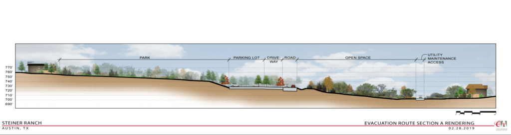
Route F would restrict parking at Westridge Park, located off Flat Top Ranch Road. On the south side of Flat Top, there would be no parking, Greear said. Residents can park to get their mail at the mailboxes located near where route F is proposed to go.
Travis County has added a 30-car parking lot for Westridge Park into its plans.
County engineers in their latest drawings and plans purposely did not align route F with Brigham Drive so traffic would naturally have to slow down.
“It is not aligned with Brigham because we didn’t want all that traffic,” Hardin said.
She added this configuration also moves more traffic away from homes, and also makes it safer as people, including children, cross the street at that intersection to go to the park.
The county said there would not be a traffic signal added to Flat Top Ranch Road because the volume of traffic they expect will not warrant one. It would not be “close to a signal,” Greear said.
Travis County collected traffic count data on January 31, 2019 and will have those numbers in time for the April 18 open house.
Added noise
“Neighbors are worried about noise. We talked about a berm which would take care of some of the concerns,” Hardin said.
County engineers said the plan would be to leave quite a few trees and they would have to abide by the requirement of developers “If take out, you have to put back. It’s the same regulation as everyone else,” Hardin said.
There is a lot of natural vegetation surrounding the area, Widacki said. Trees, earth and vegetation absorb sound. “We would implement a berm,” Widacki said.
“The closest distance this road is from houses is (about) 175 feet,” Greear said. The three closest homes are some 200 feet from the route, and “would be most affected by traffic, but no more than Flat Top,” Greear said.
The houses in the area already have some noise because of Flat Top Ranch Road, Hardin said.
Noise is dissipated over distance, Greear said.
“Two lanes of 30 mile an hour road, you’ll get some tire noise. The higher the speed the more pitch,” he added.
The proposed speed limit would be designated at 30 to 35 miles an hour, Greear said.
“We don’t want noise to be an issue,” Hardin said. “This is designed to lessen the noise.”
Sight of road
“An earthen berm takes away more of the noise. Vegetation on top of that takes care of vision,” Greear said.
County officials do not think the road will be very visible.
“If you really look at it, (you’re) not going to see that road (for the most part),” Hardin said.
Both Hardin and Greear expect the road to have less traffic than Steiner Ranch Boulevard.
Route F would “not have near that much volume,” Greear said.
Flat Top Ranch Road is smaller at 40 feet wide and Steiner Ranch Boulevard is 44 feet wide, Hardin said.
Additionally, “we don’t anticipate cut-through traffic,” Hardin said. “People who live near here will want to use this road.”